

Saguaro National Park is a treasure trove of Sonoran Desert life and hiking trails separated down the middle by the city of Tucson.
It is, accordingly, a favorite spot for locals looking to get out of the city and stretch their legs. Equally, passers-by cannot help but be beckoned in by the large, ancient saguaro cacti that always looks like its waving.
I fell in love with Saguaro NP during my first visit as a photographer for the National Park Foundation in 2021. The unique desert landscape provided endless possibilities for creative compositions.
In this guide to Saguaro National Park, I will explain everything you need to know for planning your visit. This includes information on the best things to see and do in Saguaro, camping, fees, and getting around in both the East and South sections of the park.
🔎 You May Also Enjoy: Saguaro National Park Photography Guide
🌵 Quick Facts About Saguaro National Park

While it is not the biggest national park by any stretch, understanding the layout of the park prior to arriving will assure an enjoyable experience.
Particularly, it is important to understand that the park is divided into Saguaro East and Saguaro West and that each offer something unique.
- Location: Arizona, USA
- Established: October 14, 1994
- Size: 91,440 acres (370 km²)
- Annual Visitors: 762,226 (2020), 1,020,226 (2019)
- Visitor Centers: Rincon Mountain Visitor Center (East) & Red Hills Visitor Center (West) (both open year-round)
- Entrance Fee: $25 per vehicle; $20 per motorcycle; $15 per individual; $80 Interagency Annual Pass
🏜 Maps of Saguaro National Park
You will find useful maps for your visit to Saguaro NP below. It is important to know that Saguaro National Park is divided into Saguaro East and Saguaro West, which lie about an hour apart. The two sections are separated by 33 miles and the city of Tucson.
Both sections have their own visitor centers and are predominantly one loop road with various trails scattered throughout.
Official Saguaro National Park Map

Above is the official park map. You can find a downloadable version of this map and others for Saguaro National Park on the NPS website.
Interactive Google Map of Saguaro National Park

We’ve also put together the interactive Google Map of Saguaro NP above. This map features all of the sights and places I mention within this blog post, as well as routes for both scenic drives.
Click here or on the image above to open the map in a new tab.
♥️ LOVE THE NATIONAL PARKS?
DISCOVER 65+ PERFECT NATIONAL PARK GIFTS
📸 Best Stops in Saguaro National Park
Saguaro NP is essentially just a large expanse of desert with a high-concentration of the saguaro cacti. Accordingly, you will struggle to find any particular “iconic view” or “top sight”, but the following are the viewpoints and trails you should make an effort to visit on your trip through the park.
If you are visiting with photography in mind, you will also find our guide to Photographing Saguaro National Park helpful in planning where and when you go.
Best Stops in Saguaro East
(Rincon Mountain District)
Cactus Forest Loop Drive

The majority of Saguaro East can be seen by driving the paved, 8-mile Cactus Forest Loop road. Along the drive are plenty of pullouts with information about the Sonoran Desert and all of the things that call it home. There are also a wide variety of trails available that all tend to connect to each other like a spider web.
If you want to get out, stretch your legs, and walk amongst the giants, consider the Desert Ecology Trail for a quick, informative walk.
Mica View Drive

Located a little less than halfway around the Forest Cactus Loop is a dirt-road detour to the Mica View picnic area. You will be surrounded by saguaro cacti wherever you go in the national park, but for some reason I just found this little sub-section to be the most photogenic.
It is also a great place to stop and have lunch under one of the many shaded picnic areas you will discover here.
Javelina Rocks

Nearly the last stop on the loop drive is a pullout with room for about 6-8 vehicles called Javelina Rocks. If you are spending sunset in East Saguaro, I recommend spending it here.
The large rocks, named after the native javelina animal, provide some interesting foregrounds for photos and clear views to the west.
DISCOVER MORE OF ARIZONA: Chiricahua National Monument
Best Stops in Saguaro West
(Tucson Mountain District)
Bajada Scenic Loop

Much like the Cactus Forest Loop drive covered in the previous section, most of the stops and highlights in Saguaro West will be discovered along the 5-mile Bajada Scenic Loop road. Be warned, however, that this is a rough dirt road!
You will not require 4WD or high clearance, but it is not recommended for RVs, motorhomes, or anything towing.
The Bajada Scenic Loop starts at Hohokam Road, 1.5 miles west of Red Hills Visitor Center. As you leave the visitor center, turn right onto Kinney Road then follow this road 1.6 miles (2.6km) to the loop’s entrance. This will have you driving the loop counterclockwise.
The loop finishes at the junction of Golden Gate Road and Sandario Road. Here you can return to the visitor center by turning left onto Sandario Road. After 0.2 miles turn left onto Kinney Road and the visitor center is 2 miles (3.2km) from here.
Signal Hill Petroglyphs
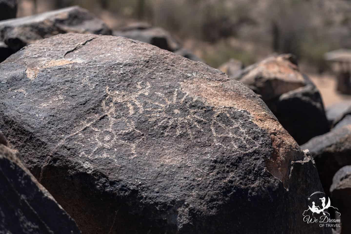
Park at the Signal Hill trailhead and take a short, quarter-mile hike to discover petroglyphs created by the Hohokam Native American tribes that used to call southern and central Arizona home.
There are also clear westerly views for sunset and picnic areas with restrooms available at Signal Hill.
Valley View Overlook

My favorite place in all of Saguaro National Park for sunset is the Valley View Overlook in Saguaro West. Park at the trailhead and walk just half a mile to be greeted by a massive view of the entire valley.
The trail will end at some benches, but the photographers among you may want to continue walking the ridge to find some more pleasing compositions that feature the saguaro cactus that you have come all this way for.
DISCOVER MORE OF ARIZONA: Grand Canyon National Park
☀️ Planning Your Visit to Saguaro NP
When to Visit Saguaro National Park
The winter is the best time to visit in terms of temperature, but the best time to visit is in early to mid-May when the saguaro cacti are in bloom.
The desert bloom only last a couple weeks, but it truly transforms the entire desert.
How Many Days to Spend in Saguaro NP
Unless you are planning to backpack overnight, one day will be enough time for most to see and enjoy the park. The thing about Saguaro National Park is that it is home to some of the oldest and highest concentration of saguaros, but it is far from the only place you will discover them.
Drive the loop roads, enjoy a picnic, take in a sunset, and continue onward to the next destination!
Getting Around Saguaro National Park
Most people will choose to simply drive the loop roads, but there are plenty of hiking trails available as well. You can also explore the park by bicycle easy enough as the loop roads are only 5-6 miles each, though there is a decent elevation gain on both.
As noted, the Bajada Scenic Loop Road of Saguaro West is not paved and is very rough. Accordingly, you will want to drive slow and it is not recommended for RVs or vehicles that are towing.
Gas and Supplies
You will not find anything besides water within Saguaro National Park, but gas and supplies are easily located all over Tucson and the surrounding suburbs.
Where to Stay in Saguaro National Park
The only option for camping in Saguaro National Park is at various backcountry sites. These require permits and should be explored further at the official NPS website.
Where to Stay Outside Saguaro NP
Tucson offers all variety of accommodation options you would expect in any major city. Self-contained campers (campervans, RVs, etc) can stay at the Wal-Mart near Saguaro East for free, which provides restrooms and Wi-Fi.
Saguaro East Closes to Vehicles at Night!

The gates to Saguaro East will close at night! In the summer, the gates stay open from 5am-8pm. In the winter, they are open from 5am-6pm.
You will still be able to exit after the gates have closed as they are on an automatic sensor system, but you will not be able to enter.
Additionally, the park is always open to foot and bicycle travel.
Where to Photograph Sunset in Saguaro National Park

You will have no shortage of westerly views in both sections of Saguaro NP. Accordingly, there are plenty of interesting pullouts available if you see a view you like.
With that said, my favorite place to photograph sunset in Saguaro NP is from the Valley View Overlook in Saguaro West. I found the high vista with a field of saguaro and plenty nearby for the foreground was the most photogenic option in the park.
Additionally, I enjoyed shooting sunset from Javelina Rock in Saguaro East as well for those who find themselves in the Rincon Mountain District section of the park instead.
Where to Photograph Sunrise in Saguaro National Park

East-facing views are more challenging to find as the Rincon Mountains will be obstructing your view of the sunrise from the entire Saguaro East section.
The place I found a good mix of saguaro cacti and clear horizon was the Sus Picnic Area in Saguaro West. A very short road will take you to the parking area but it is from this road itself that I found my favorite place to photograph sunrise in Saguaro NP.
🥾 Useful Tips for Visiting Saguaro NP

- Bring appropriate footwear: If you plan on doing any walking at all, be sure you are not wearing anything open as everything in the desert is sharp! There are also a lot of rattlesnakes in the Sonoran Desert.
- Plan ahead: Read this guide and make sure you understand the park’s limited hours, and have an idea of where you will be staying prior to arriving.
- It gets hot: The dry desert heat can quickly cause dehydration and the sun can be intense. Make sure you carry plenty of water and sunscreen.
- Leave no trace: Please be respectful of the park. Keep to the trails, dispose of waste properly, and leave any plants etc. that you find.
- Desert critters: The desert is home to venomous snakes, scorpions, spiders and centipedes. Be cautious where you tread and wear appropriate footwear.
- Drive carefully: The roads can be busy and you may share them with wildlife. Please adhere to speed limits and drive responsibly in Saguaro National Park.
🤗 Fun Facts About Saguaro National Park

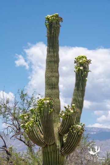
- The oldest known cactus in the world was found in Saguaro NP. “Old Grandaddy” was around 300 years old when it died in the 1990s. At an impressive 40 feet tall and with 52 arms, the gigantic cactus was the most visited and photographed in the park.
- Saguaro cacti are the largest cacti in the US, typically growing to around 40ft tall. However, the largest saguaro cactus ever measured reached a mighty 78ft tall!
- Despite their enormous size, saguaro cacti grow very slowly. It can take 10 years for them to reach 1 inch in height and 200 years to reach full height.
- The saguaro cactus doesn’t flower until it’s 70 years old and won’t get its first arm until it is 95-100! While some cactus have dozens of arms, some don’t have any – why this occurs is still a mystery!
- The only place in the world that these giant cacti can be found is in the Sonoran Desert.
- While famed for the saguaro cacti, the national park is also home to 1161 other species of plants! These range from lower elevation desert vegetation such as ocotillo and creosote to oak, ponderosa pine, and Douglas fir in the higher elevation Rincon Mountains.
❓ Saguaro National Park FAQs
Below is a list of the most commonly asked questions we receive from people planning a trip to Saguaro National Park.
Is Saguaro National Park closed at night?
The Rincon Mountain District of Saguaro known as Saguaro East is closed to vehicle traffic at night, but is open 24/7 to foot and bicycle traffic.
The Tucson Mountain District known as Saguaro West is technically only open sunrise to sunset, but there are no gates to prevent access after hours.

How much time do I need for Saguaro National Park?
Most people will not need more than a day to explore both the east and west sections of Saguaro NP.
Can you drive through Saguaro National Park?
Yes, there are two scenic drives through Saguaro National Park; the Cactus Forest Drive (East Saguaro) and the Bajada Loop Drive (West Saguaro).
How far is the drive from Saguaro East to Saguaro West?
33 miles. Expect it to take about an hour to drive from one to the other.

How long is the Bajada Loop Drive?
5 miles of unpaved road, plus a one-mile detour to Golden Gate road is available.
Do I need 4WD for the Bajada Scenic Loop?
No – the road is unpaved and quite rough, but 4WD is not required. However, it is not recommended for oversized vehicles.
How long is the Cactus Forest Loop Drive?
8 miles, all paved.
Is Saguaro National Park worth visiting?
Honestly, only if it is on your way. The reason I say this is that you will see saguaro cacti all over central and southern Arizona, and in much prettier settings. If you want to see and photograph this iconic desert feature, consider spending time in the Superstitions Mountains outside of Mesa/Phoenix instead.
However, if you are already driving through Tucson, then it is absolutely worth taking the time for a scenic drive through Saguaro NP!
Which side of Saguaro National Park is better?
West Saguaro is smaller and at a lower elevation with a higher density of saguaro cacti. It is, therefore, a better option if you’re short on time.
East Saguaro is larger and more mountainous. Of the 165 miles of hiking trails within the two sections of the park, 128 miles of these are found in East Saguaro. It is also the only region where backpacking is permitted. Therefore, East Saguaro is a much better option for hikers and those with more time to explore.
Final thoughts on Saguaro National Park
The two of us work very hard to create these free travel guides to help you plan your dream vacation. If you think we’ve done a good job and would like to say thanks, please consider clicking the donate button below 🙂

While it may not be the most photogenic or diverse national park in the country or even the region, there is something incredible about looking out over a valley of these ridiculous plants. I found myself constantly playing “the cloud game” where you swear that cactus looks like someone or something.
As always, I hope you have found this guide valuable in planning your visit to Saguaro National Park. If there is anything that needs correcting or praise, please feel free to do so in the comments below!
Enjoyed this guide to Saguaro National Park? Pin it! 🙂


